Home | Gallery | AboutUs | Software | Rates
On Saturday evening, December 20, 2008, Continental flight 1404 (N18611) crashed on takeoff from runway 34R at Denver International Airport, bound for Houston, Texas. There were 38 injured people of the 115 on-board and only five of those remained hospitalized on Sunday Afternoon. According to preliminary information, the plane veered off the runway early in the takeoff roll, coming to rest approximately 200 yards from the runway centerline and erupting in fire. This was the most serious accident in the thirteen year history of DIA.
We have created two preliminary 3D animations of Continental Flight 1404 to aid in the visualization of what happened. Due to a lack of detailed information, it is not possible to depict the events of flight 1404 without some level of incompletness or inaccuracy. Eventually, with the aid of the cockpit voice recorder (CVR) and flight data recorder (FDR) data, it will be possible to increase the fidelity of the reconstruction. The FDR will contain position data (latitude and longitude from GPS receivers) and, more importantly, will contain accelerometer data for all three axii of the aircraft. Provided that the data is clean and sampled at a high enough rate, the acceleration data can be integrated over time to generate an accurate pushback, taxi and takeoff flightpath for the accident aircraft.
There will be security cameras at DIA airport which will likely have at least portions of the pushback and taxi path taken by the aircraft. In a best case scenario, the security cameras may have footage of the actual takeoff roll and crash. It is important to check cameras at places like toll booths and parking lots, there are many pivotal data sources in a reconstruction such as this that sometimes go un-noticed. Ideally, the NTSB or FAA will have a satellite image acquired of the accident scene to mitigate any conjecture as to the path of the aircraft as it departed the runway. Surveys and photographs can certainly provide that information, but a true aerial photo is often much better in terms of recreating the accident as a whole.
Because the accident was at night, reconstruction will be critical with respect to signage, runway markings, lighting and other environmental cues available to the pilots (captain and first officer). Radar tracking data from the Denver airport facility may also provide information regarding the flight path. Key elements of this accident scenario will be the events that occurred prior to the pilots positioning the aircraft on the runway for takeoff. Sterile cockpit procedures, radio communications, distractions and checklist procedures will be of key focus in determining the decision process that was underway in the cockpit.
This early in the investigation, it is impossible to tell if environmental factors played a key role, or if the primary cause of the accident may have been structural or mechanical failure. Critical airspeed calls for "V1", "V2" and "rotate" and the timing of these airspeeds with respect to the events during the takeoff roll will be useful key factors in the aborted takeoff decision.
We have a detailed surface map of the Denver International Airport, accurate to within a few meters and sampled at 1 meter increments. Included in our reconstruction is the accurate placement of over 3500 runway and taxiway lights. At present time, we are animating a sample takeoff roll and departure from the runway, to illustrate to potential of this method of visualization. Once data becomes available, we will be able to integrate things such as the CVR, FDR, security cameras, photographs and witness statements to increase the accuracy of our reproduction.
The terrain base model is created from USGS NED (National Elevation Dataset, a.k.a. DEM) 10m data. The elevation model of denver airport is a basic starting point and would be best visualized with additional data acquisition such as LiDAR or IFSAR. The DEM model is not sufficient alone for recreating the terrain surface because the data was sampled at a time before the airport had been constructed. A moderate amount of "landscaping" has taken place in order to get flat runway surfaces. A factor in the accident is the elevation drop just west of the runway which would likely unload the landing gear momentarily until the aircraft again settles down to the surface.
By analyzing photos taken of the crash site as well as satellite imagery, we have estimated the location of the crash site at 39 52 35.4 N, 104 41 22.7W. The aircraft departed the north-oriented runway to the left (west) near the taxiway WC (whiskey-charlie) and came to rest a short distance north of fire station #4, located on the airport between runways 34R and 34L.
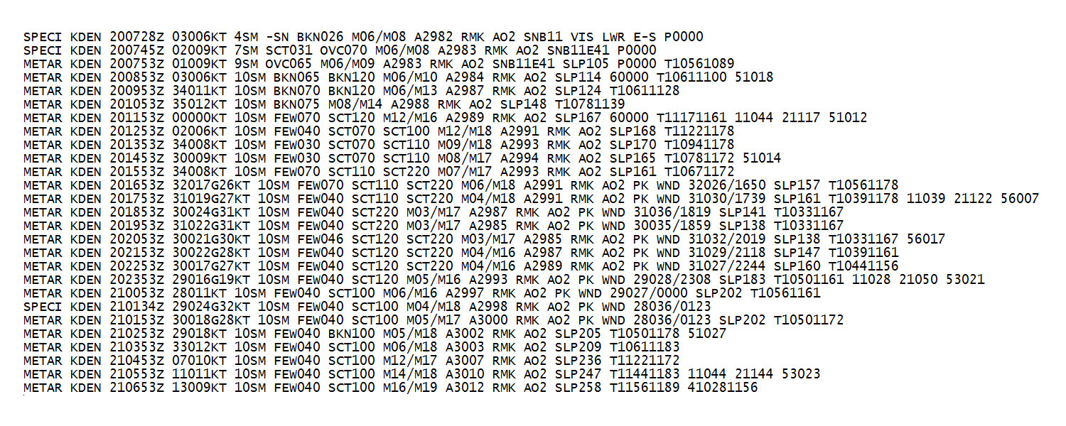
Below is the KDEN METAR (routine aviation weather report) reported data for December 20th, 2008. The time format is in "Zulu", which is 7 hours later than local time. There is a SPECI (special) observation at 6:34pm (0134Z) which corresponds approximately to the time of the accident, the winds were out of the west (290 degrees) at 24 knots gusting to 32 knots. The remarks section indicates that the winds were 280 degrees at 36 knots at 0123Z. The SPECI and remarks associated with it are most likey observations taken because of the accident. It is typical for a weather observation to be recorded when an accident occurs.
Copyright 2010 Exosphere3D.com